ZIP lookup uses Census ZIP boundaries (2010) and the city’s 2022 district map. Split ZIPs list districts largest share first.
Written by A. Addicks, a concerned resident.
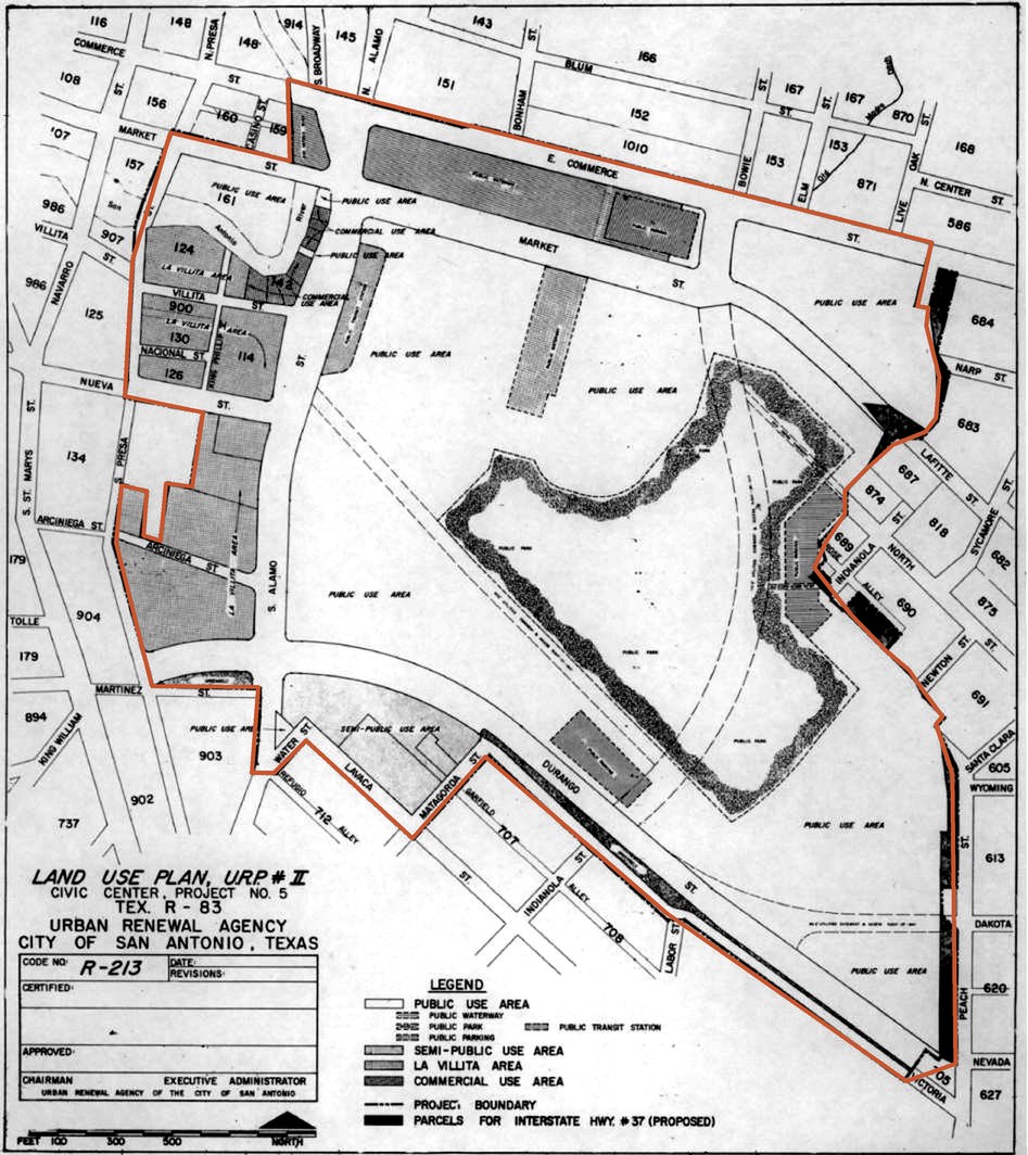
Urban Renewal Agency, Land Use Plan, Civic Center Project No. 5, 1966. Inside the project boundary, traced here in red, the cleared blocks are relabeled “public use area.”
The same ground, again
The city paid to give 13 acres away. Now it’s paying 180 times as much to get them back. In the 1960s, San Antonio paid about $25,600 an acre for cleared Germantown land and gave it to the State of Texas for a museum. The University of Texas System ended up with it. In 2026 the city is paying the UT Regents up to $60 million, about $4.6 million an acre, to buy the same land back for an arena. With interest, it comes to $115.7 million, paid from property taxes in the Midtown TIRZ. Since 1964, the city has made five promises on this ground. All five came back for more public money.
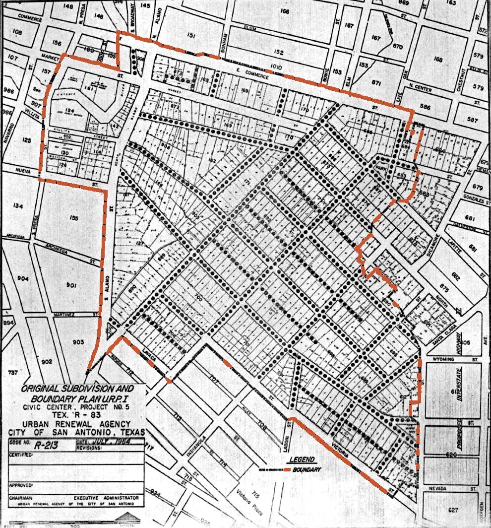
Urban Renewal Agency, Civic Center Project No. 5, July 1964. The boundary line is the only color added to the scan.
Report card
The ground inside the 1964 line, 1964–2026
F
Overall
Assignment
What was promised
What happened
Public money again
Grade
1964Germantown cleared → About 1,600 people moved; the city pays a third of the cost, $5.79 million
A world’s fair for the whole city
HemisFair ’68 lost a reported $7.5 million
About $1.61 billion more on the same ground since, in today’s dollars
$109 million in upgrades; about $125 million more under study
F
Teacher’s comments
Different councils, same four steps. The Spurs, Landry’s, the Grand Hyatt and Zachry keep the revenue, minus rent. The city covers the losses with public money: about $110,000 a day.
Record
5 of 5
sent back for more public money
3 of 5
torn down or abandoned by the tenant they were built for
180×
the 1960s price per acre, to get the museum land back
My grades. The facts behind them are in the ledgers.
— A. Addicks
Sources: City ordinances 34989, 35199 and 37347 (1966–69); KSAT (Sept. 5 and Sept. 11, 2026); San Antonio Report (Sept. 11, 2026); KSAT (Jan. 16, 2026); Urban Renewal Agency survey (1964); Handbook of Texas; Heywood Sanders, San Antonio Current (May 9, 2022), citing city and Arthur Andersen figures; San Antonio Business Journal (Oct. 22, 2026); city convention center official statements; City of San Antonio FY2025 financial reports and budget (costs and income on the 1964 ground, about $40 million a year net); arena term sheet (Aug. 21, 2025). Full accounts are in the ledgers.
Show your work.
A grade without sources is just an opinion. So I went looking for them: the ordinances, deeds, budgets and campaign filings behind every number here, all public and free to look up. Some of those records have my family’s names in them. That’s how I started reading the rest.
The first time I spoke at the dais in City Council chambers, I had two minutes. I stumbled over my own name for twenty seconds, then ran through my speech to a row of people who seemed mildly interested at best. That’s what this city offers its residents: a turn at the microphone, while the deciding happens somewhere else. I wanted to know how it got set up that way.
In 1964 the city drew a line around 140 acres of homes and businesses beside downtown and called it a slum. That label unlocked federal urban renewal grants, which cleared it for HemisFair ’68. About 1,600 people lived in this area known as Germantown, a mix of Mexican American, German and Black families.
Urban Renewal Agency, Civic Center Project No. 5. City of San Antonio Municipal Archives. See the ground →
The fair’s theme (“the Confluence of Civilizations in the Americas”) required removing the real thing it claimed to celebrate. No single villain made that call; the rules did. Until 1977 the charter had every council seat chosen by the whole city instead of by district. A business group, the Good Government League, picked a slate each election, and the North Side’s ballots could carry it; neighborhoods that disagreed lost every seat. Pay for the job stayed next to nothing until 2015, so only people who could afford it served. The 1964 bonds for the convention center and arena went to a vote of property owners only, while three of every four households there rented. Those rules decided whose interests counted, and the same ones keep winning on this ground: about $1.61 billion in public money since, in today’s dollars.
Deciding who belongs on this land is an old habit. Before any flag, the Payaya and other Coahuiltecan peoples lived along this river, which they called Yanaguana. The Spanish crown claimed it next and gathered them into missions. Mexico, the Republic of Texas, the Confederacy and the United States each took it over, and each time those already here were handed new rulers. Five flags passed over these people until 1964, when the city wanted Germantown’s blocks for a world’s fair and the incentive was finally enough to displace them.
My mother’s family reached this river twice.
The first time was 1718, with a soldier named Francisco Hernández. In the 1840s one of his descendants, María Susana Hernández, married Thomas Addicks, the county clerk. Their name came down to my grandfather.
The second time was November 1913. A one-year-old was carried across the bridge at Eagle Pass, one of hundreds of thousands who came north during the Mexican Revolution. He was my grandmother’s father. In 1943 the Army drafted him while he was still a citizen of Mexico. In 1952 he petitioned to become an American. One line never crossed a border; the border was drawn around them. The other crossed it on a bridge. Most South Texas families can tell both stories.
Then I got metiche. The archives that hold my ancestors hold the city’s too. That’s how I found Germantown.
I told my mom recently that reading documents as old as she is has changed how I see this city. None of it happened very long ago, and the same decision-making apparatus still holds the reins. In those files I kept finding human beings: names on deeds, families counted and moved. The land taken from them has been run at a deficit ever since, on the books and off them. In 1966 and 1969 the city paid about $334,000 to give 13 acres of it to the State. In 2026 it agreed to pay $60 million to get that land back. A business that did that would be under new management.
San Antonio needed that fair. And some of what it left paid off: the Tower, the parks, a busy convention center. But it’s an old pattern: decide first, put a public good up front, and keep the ground public and untaxed while a few private players profit. Some of the rules have changed since then: by 1970 the Supreme Court had ruled that renters get a vote too. The pattern is still here. Here’s how it played out:
Gatekeep San Antonio
The moveThe rule that stops it
Claim the land first.The council claimed Germantown for a convention center in March and May 1964. It called the neighborhood blighted in August.
The ruleAn independent economic study
Let owners decide.Only property owners could vote on the 1964 bonds. Three of every four households on the land rented.
The ruleA public vote on the city’s share
Move people out cheap.Relocation money was capped at about $850 a person, for about 1,600 people.
The ruleNo one pushed out, and housing nearby people can afford
Give the land away, untaxed.The city paid $334,059 for 13 acres and handed them to the State. Today 24 of the 25 parcels inside the 1964 line pay no property tax.
The ruleTaxes, or payments in their place
Let it run at a loss.In 2024 and 2025 the convention center’s debt payment was bigger than everything it took in. $537M is still owed, through 2042.
The ruleA lease as long as the bonds
Buy it back and start over.In 2026: $60M for the land it gave away, and about $800M in public money committed to a new arena on it.
The ruleThe land handed back to the people at no cost
Better people won’t break the pattern on their own. Different rules will.
The short version · 5 min
Read the bold line at the top of each page. If one catches you, stay and read the whole thing.
Part I
The Story
Chain of title · eleven generations on the river
The short version · 5 min
Read the bold line at the top of each page. Follow the “Continue” link at the bottom of each page.
The story · 20 min
Every part in order, starting here, with each ledger in brief. Follow the “Continue” link at the bottom of each page.
The full experience
Everything, in the order it happened, starting with the family on this river. Every receipt is linked.
Before any of this was a parcel, it was Yanaguana, home to the Payaya and other Coahuiltecan peoples. In 1718 they received the Spanish here, and everything my family built, kept, and lost on this river runs downstream of that welcome. It’s an inheritance with a debt attached, owed to people who are mostly missing from the archive I’ve been reading. Theirs is a loss I can’t document the way I can document a deed, and it isn’t mine to tell.
Eleven generations, from an alférez in 1718 to a woman who chose his line’s name, on the same river where the city cleared Germantown.
It starts with a man: Francisco Hernández, alférez of San Antonio’s first garrison in 1718. Four generations later his line reached a woman, María Susana Hernández, who married Thomas Addicks around 1841. Five Addicks men carried the name through the 20th century. By the time I reached for the name, it was a choice I made.
I started out checking a family story my mother told and found María Susana Hernández instead. Her family had been on this river since 1718. I did what any history major with no kids would do: I went Henry Louis Gates Jr. on my own ass. Eleven generations, on land grants, court testimony, wills and baptisms. The same archives hold the city’s records: the ordinances, the bonds, the deeds to the ground it cleared in 1964.
Five years ago I couldn’t have told you much about my grandparents. Now I notice how few people know their great-grandparents. I expected the paper to run out around 1800. It didn’t. It turned up Thomas Addicks. He was born in Pennsylvania to a German father and an Irish mother. He spoke Spanish well enough to interpret for a U.S. general. Mexican authorities once jailed him on suspicion of conspiring with Texans.
Thomas Addicks’s map of the route from San Antonio to Presidio del Río Grande, signed as interpreter to Gen. Wool, September 20, 1846. Beinecke Rare Book & Manuscript Library, Yale. Tap to enlarge.
My first ancestors here were Francisco Hernández and Ana García; their son Andrés names them in his own petition in 1752. In 1717 the commander of the expedition that founded San Antonio listed his soldiers, and the first name is “Francisco Hernández, Alférez, who was going with his family,” with two sons, Nicolás and Francisco, enlisted beside him. On June 14, 1718, six weeks after the founding, the same alférez heads the first roll of San Antonio’s garrison. Every parish record since points to him as my Francisco. The one document that would close it, naming Ana as the alférez’s wife, hasn’t surfaced. What I can trace is the paper trail: a chronological record that starts in the 1700s and runs, document by document, to this ground today. In those three centuries, San Antonio has answered to Spain, Mexico, the Republic of Texas, the Confederacy and the United States.
The record · January 28, 1765
Andrés Hernández and Juana de Hoyos, “consortes, y vecinos de esta Villa de San Fernando y este Presidio de San Antonio de Béxar,” swear before the town magistrate that the herd held by their son Miguel is his alone: 24 breeding mares, a stallion, 12 fillies and 7 colts, grown from a mare his godfather gave him in 1748. They ask that it be written down, “because we are mortal,” so their heirs won’t fight over it. The brands are drawn in the margin. Andrés didn’t sign; Silvestre Joaquín de Soto signed at his request.
Béxar Archives, Briscoe Center for American History, University of Texas at Austin. Summarized from the original Spanish.
It starts with me. Follow the river backward, one generation at a time, until it reaches Francisco Hernández in 1718. Tap any generation to open its record.
Eleven generations on the river · from me to Francisco Hernández
The Addicks namedaughter of
daughter of
son of
son of
son of
son of
The Hernández linedaughter of
son of
son of
son of
Each name is the child of the next one along the river. Every link, back to Francisco, is in church, land, court and civil records.
Open the full family record10 generations · 21 documents · 14 maps and images · the downtown timeline, 1718–2030
My family, one generation at a time
What was happening downtown in the same years
What the city decided
ME · ADRIANNA ADDICKS→ONE GENERATION AT A TIME→FRANCISCO HERNÁNDEZ · 1718
You are here
Present
Adrianna Addicks
I started with a family story and kept going. I found it in hundreds of years of documents. Six generations back, María Susana Hernández married Thomas Addicks. Ten generations back, the line reaches Francisco Hernández, the ensign of San Antonio’s founding garrison in 1718.
I took my mother’s maiden name as an adult. It comes from a marriage in 1841–42, six generations back.
2025–2030 Downtown
In November 2025 voters passed Proposition B. The new arena goes on the Institute of Texan Cultures site, the Texas Pavilion from the 1968 fair. The Spurs put in at least $500 million. Bexar County puts in up to $311 million from a hotel and car-rental tax increase. The city puts in up to $489 million in bonds, repaid from Spurs rent, the Hemisfair tax increment district, and state hotel taxes. The Spurs play at Frost Bank Center, the east side arena from 2002, and the Spurs’ goal is to move in July 2030 (the city’s 2025 timeline said 2032). It would be the second HemisFair-era building taken down for something bigger. The first, HemisFair Arena, the Spurs’ first home, came down in 1995 for the convention center. See the official concept renderings by Populous, as published in the San Antonio Report (Nov. 2024) →Sources: City–Spurs term sheet (Aug. 2025), as reported by Texas Public Radio; Bexar County election results (Nov. 2025).
Present Downtown
Hemisfair is now a downtown public district with parks, the Tower of the Americas, the expanded Convention Center, and surviving historic buildings. The Spurs currently play at Frost Bank Center on the east side; Hemisfair continues to be redeveloped.
1995 Downtown
HemisFair Arena is demolished for expansion of the San Antonio Convention Center, two years after the Spurs moved to the Alamodome. The arena had stood on the former HemisFair ’68 grounds since 1968.
1993 Downtown
The Alamodome opens May 15, 1993, on downtown’s southeastern edge. The Spurs move from HemisFair Arena for the 1993–94 season, while their former arena remains standing at HemisFair until 1995.
1973 Downtown
The Spurs moved to San Antonio in 1973 and made HemisFair Arena their home. The former fair arena, opened for HemisFair ’68, became the team’s San Antonio home as the city entered a new era of professional basketball.
b. 1963
Lourdes Addicks
My mother, born in Bexar County. Her maiden name is the one I chose to carry as an adult.
Daughter of Eddie and Henrietta.
1968 Downtown
HemisFair ’68 opened April 6 and ran through October 6. The Tower of the Americas, Convention Center and Arena, Institute of Texan Cultures, U.S. Pavilion, international exhibits, and an extension of the River Walk transformed the cleared site into a six-month world’s fair.
1966–1968 Downtown
Clearance for HemisFair began in 1966 and proceeded block by block while construction followed. Homes, businesses, streets, and community institutions disappeared across the 92.6-acre site; a small group of historic structures was preserved.
1964 Downtown
The last snapshot before the clearing: Germantown had grown for a century by then, with simple 1850s caliche houses joined over the decades by late-Victorian mansions, home to a mix of German, Alsatian, Mexican, Polish, and African American families. Rodfei Sholom Temple and St. Michael’s Church stood a block apart, family grocers and a hotel lined Sycamore Street.
1937–2007
Eddie Addicksm. Henrietta
My grandfather. Born in San Antonio in 1937; he was twenty-nine when the city began clearing Germantown for HemisFair.
Son of Antonio and Isabel. Married Henrietta Gloria Ortiz, daughter of Ramón Peña Ortiz. Died in San Antonio in 2007.
1949 East Side
The Bexar County Coliseum opens on the east side; it was renamed Freeman Coliseum later in the 1950s. Brothers Harry and Joe Freeman organized ranchers and civic boosters behind the idea, Bexar County broke ground in 1947, and built it as a public facility for the stock show and rodeo. Downtown and Germantown remain dense with houses and shops along the river.
1911–1990
Antonio Addicksm. Isabel Estrada
Born in San Antonio in 1911, when the family had been on this river for close to two centuries.
Son of Eduardo and Marciana, born September 2, 1911. Married Isabel Estrada, born 1918 in Mexico. Died January 11, 1990, in San Antonio.
1873–1934
Eduardo Addicksm. Marciana Algarez
Born February 15, 1873, in Wilson County, Texas. Died in San Antonio in 1934.
Son of Nepomuceno and Juanita María. Married Marciana Algarez, born 1892 in Monterrey, Mexico. Died December 19, 1934.
1850s Downtown
Homes, farms, and new neighbors take root near the San Antonio River as the Germantown community grows.
1842–1914
Nepomuceno Addicksm. Juanita María López
Son of María Susana and Thomas Addicks, born in Texas in 1842. He worked as a laborer and died in San Antonio in 1914.
1870 marriage1914 death certificate, Reg. No. 23648
Married Juanita María López, born 1843 in Mexico, on August 19, 1870. Died December 21, 1914, in Bexar County, and buried at San Fernando Cemetery. Juanita died in 1906 in Delta County, Texas.
1811–1853
María Susana Hernándezm. Thomas (Jacob T.) Addicks
Baptized in San Antonio in 1811. Sometime between 1841 and 1842, during the Republic of Texas, she married a man named Thomas Addicks. This is the marriage that brought the Addicks name into the line. More than a hundred and fifty years later I chose that name for myself, not knowing it would lead me back to the Hernández name, three hundred years deep.
1811 baptism1841–1842 marriage1846 map, Beinecke
Born May 20, 1811; died around 1853. Her husband is recorded across different documents as Thomas H.O.S. Addicks, Jacob T. Addicks, and Jacob T. O. Addicks, born 1812 in Pennsylvania to a German father and an Irish mother, most likely the same man under different parts of his name.
The only document found so far in Thomas’s own hand, not a record he filed as county clerk (1841–1848), is a map of “the route from San Antonio to Presidio Rio Grande,” dated September 20, 1846, at Yale’s Beinecke Library. He signed it “Interpr. to Genl. Wool, Comdg. Centl. Divn.”: interpreter to Gen. John E. Wool, commanding the Central Division, days before Wool’s army marched to Presidio del Río Grande. He drew it on the back of a blank Bexar County form. He knew that country. By his own sworn account, he reached the Beales colony on the Rio Grande in 1834 and was later imprisoned by Mexican authorities on suspicion of conspiring with Texans.
His notes on the route: “Rio Frio banks very steep, a road to be made. Liona Creek, a bridge required. Nueces River, a bridge required. Rio Grande, a boat required; in low stage fordable.”
Thomas H. O. S. Addicks, Map of the Route from San Antonio to Presidio Rio Grande, September 20, 1846. Yale Collection of Western Americana, Beinecke Rare Book and Manuscript Library.
b. 1790
José Felipe Hernándezm. Candelaria Vidaurre
Born in San Fernando de Béxar. Father of María Susana, the woman whose marriage changes the name.
Recorded in the family tree as José Felipe del Sacramento. Born 1790; Candelaria Vidaurre was born in 1792.
1744–1816
José Andrés Hoyos Hernándezm. Antonia A. P. Zepeda
Son of Andrés and Juana de Hoyos, named for his father and carrying his mother’s surname: Hoyos. Two men named José Andrés, father and son, which is exactly how a generation can seem to disappear in these records.
Baptismal recordAncestry-compiled tree
Born 1744, died 1816. Married Antonia A. P. Zepeda (1747–1805), recorded as Anselma Zepeda on their son’s baptismal record, most likely the same woman under different parts of her name. Father of José Felipe.
A roll of Béxar ranchers from the years of the American Revolution, compiled by the historian Robert H. Thonhoff from Spanish records dated 1778 to 1782, lists a Joseph Andrés Hernández alongside a Francisco Hernández and a Joseph Placido Hernández. One of Thonhoff’s sources, an April 28, 1781 roundup record in the Bexar Archives, names the pastures of San Bartolo, the family ranch. If the family tree’s 1769 death date for the elder Andrés holds, the Joseph Andrés on that roll is this man, the son. That is not yet proven: it rests on the tree, and the roll itself doesn’t say which one it means.
fl. 1726–1765
Andrés Hernándezm. Juana de Hoyos
In 1758 Andrés and Luís Antonio Menchaca settled their competing claims to the wedge of land where Cibolo Creek meets the San Antonio River. Their compromise is the oldest land grant on record in the Spanish Archives of the Texas General Land Office. Andrés took the eastern part and called it San Bartolomé. The deed itself says why Andrés had a claim at all. He was living at San Bartolomé and had settled it more than five years before, on land that Governor Carlos de Franquis had granted to “el difunto su padre,” his late father, more than twenty-two years earlier. That line, written down in 1758 and not assembled after the fact, is what ties Andrés to the man who came before him. The deed doesn’t name his father; Francisco’s 1751 estate papers do.
1758 land grant, GLO Spanish Archives1758 deed: “his late father”1765 herd declarationJuana’s 1785 will
The deed was executed at San Fernando de Béxar on April 12, 1758, before the alcalde Joseph Manuel de Santa María. It sets out each side’s case before the terms. Menchaca had sued over San Bartolomé because it fell inside the fifteen sitios and twelve caballerías granted to him by sale through the crown’s land judge for New Spain (the Juez Privativo). Andrés’s defense, as the deed records it: “se defendió a causa de hallarse viviendo en dicho paraje, como es constante, y tenerlo poblado hasta la presente más ha de cinco años, por merced que le hizo el Gobernador Don Carlos de Franquis al difunto su padre, de cuatro sitios y ocho caballerías de tierra en el referido paraje de San Bartolo, más ha de veinte y dos años.” In English: he defended himself because he was living at the place, as was well known, and had settled it more than five years before, under a grant Governor Carlos de Franquis made to his late father of four sitios and eight caballerías there, more than twenty-two years ago. Franquis governed Texas in 1736–37, which fits. This is the deed’s account of Andrés’s position, not a separate sworn deposition. If he testified, it would be in the lawsuit behind the deed, “Heirs of Francisco Hernández vs. Luis Antonio Menchaca” (Bexar County Spanish Archives, Litigations no. 1, December 30, 1757), which hasn’t been pulled yet.
The grant is the Compromise Donation Between Luís Antonio Menchaca and Andrés Hernández, dated April 12, 1758. It referred back to earlier grants to the same two men. Thonhoff describes both as sons of soldiers of the Alarcón expedition that founded San Antonio de Béxar in 1718, and his Handbook of Texas entry names Andrés as the son of Francisco Hernández and a longtime soldier of the Béxar presidio. Rancho San Bartolomé, sometimes called San Bartolo, lay on the west bank of Cibolo Creek near present-day Panna Maria, Czestochowa, and Kosciusko, in what are now Karnes and Wilson counties: four leagues and eight caballerías, about 18,599 acres. Menchaca’s ranch, San Francisco, lay west of it, and between the two was Pataguilla, a ranch deeded to the Indians of Mission San Juan Capistrano.
Rancho San Bartolomé lay on the west bank of Cibolo Creek, from the Rincón, the corner where the Cibolo meets the San Antonio River, up the creek toward the fort. The grant was never surveyed and has no plat, so the shaded area shows only where the 1758 grant file and Thonhoff place it, not its bounds. Menchaca’s San Francisco lay to the west, with Pataguilla between; their positions aren’t mapped. Rivers: USGS National Hydrography Dataset. County lines: U.S. Census TIGER. Fort: Texas Historical Commission marker, “about 2.5 mi. N on Cibolo Creek” from Cestohowa; garrison dates per the marker and the Handbook of Texas.More from the grant file
The grant file itself, which the Land Office holds as file no. 98, shows how the deal was made. The land in dispute, fifteen leagues and twelve caballerías, had been sold at auction to Menchaca. Andrés accepted the sale, and in return Menchaca gave him four leagues and eight caballerías: San Bartolomé, “where he has his ranch,” the Rincón pasture beside it, and land up the Cibolo. The petition was received on February 25, 1758, by the captain of La Bahía acting for the governor, and the deed was made at Béxar that April. Menchaca signed it. Andrés did not; another man signed “at the request of Don Andrés Hernández.”
The same file carries the land’s later history. In 1834 José Casiano, a Béxar merchant, said he had bought the larger shares of “the Hernández grazing lands” and asked the court to call in anyone else with a claim to San Bartolomé. Notices went out, and the alcalde of Goliad reported that no one appeared. The papers were certified at Béxar in April 1840 and deposited in the Texas General Land Office that December.
Filed a herd declaration in 1765 protecting his own son’s cattle inheritance. Juana de Hoyos was born in Monclova, Mexico, in 1709. She made her will in San Antonio on April 13, 1785, the year she died; the county files it under her name, as Juana de Hollos, with Andrés named as her husband. The family tree gives his death as 1769, so whether he was still living when she wrote it is an open question. The family’s Ancestry-compiled tree records him as José A Hernández, the same man under a different part of his name.
1731
Who gets called a founder
Thirteen years after the mission, in 1731, sixteen Canary Islander families arrived, were granted hidalgo status by the Spanish crown, and have been credited as San Antonio’s founders ever since, even though the presidio and the mission were already standing when they got here.
1731 San Fernando de Béxar
Canary Island families join the military and civilian community already living at Béxar and establish the villa of San Fernando de Béxar. Main Plaza, town lots and a civil government take shape between the San Antonio River and San Pedro Creek, while the San Pedro acequia carries water to homes and fields. Before San Antonio spread outward, it followed the water.
1718 Downtown
The San Antonio River and the surrounding landscape at the time Mission San Antonio de Valero was founded. Native trees such as cypress, cottonwood, pecan, mesquite, and live oak lined the river.
1717–1751
Francisco Hernándezm. Ana García
An alférez named Francisco Hernández, an ensign of the Presidio de los Tejas, enlisted with Alarcón in 1717 “with his family,” his sons Nicolás and Francisco beside him, and stood as alférez on the first roll of San Antonio’s garrison on June 14, 1718. By 1724 Francisco Hernández and Ana García were godparents at the presidio. He was buried at San Fernando on October 4, 1751, a widower. Every record points to one man; the document that would prove it hasn’t surfaced.
Castañeda, Our Catholic Heritage II (1936)Céliz diary, ed. Hoffmann (1935)Valero & San Fernando registers
Proven from primary records: Ana García was his wife (godparent entries 1724–1734; his 1751 burial calls him her widower), and Andrés and Diego were their sons (1751 estate file, 1757 burial). Ana was alive on August 3, 1734 and dead by 1751; her burial has not been found.
Inference, labeled: that the alférez of 1717–18 is this Francisco. Same name, same company, a son Francisco “el mozo” at the same presidio, and the same founding families as godparents for thirty years. No record yet names Ana García as the alférez’s wife.
Birth years and birthplaces in online family trees (1677; Chihuahua; Tobarra, Spain) are unsourced and are not used here.
Sources for this family record
Francisco Hernández, 1717–1751
Carlos E. Castañeda, Our Catholic Heritage in Texas, vol. II (1936), pp. 84–85; Fray Francisco Céliz, Diary of the Alarcón Expedition into Texas, 1718–1719, trans. Fritz Leo Hoffmann (1935), p. 41 n. 68 (AGN, Provincias Internas, vol. 181, f. 152); Mission San Antonio de Valero and San Fernando parish registers (Ancestry, collection 61845); Béxar Archives, estate of Francisco Hernández, 1751–52. Also: Frederick C. Chabot, With the Makers of San Antonio (1937).
The line, 1758–1914
Bexar County marriage records; Nepomuceno Addicks’s Texas Standard Certificate of Death (Register No. 23648, 1914); an Ancestry.com family tree compiled from vital, census, and cemetery records.
Thomas H. O. S. Addicks, 1834–1848
His sworn petition to the Congress of the Republic of Texas, Committee on Public Lands, filed November 15, 1841, Travis County (Republic of Texas memorials and petitions): a native of the United States, he joined the Beales Río Grande (“Dolores”) colony in the winter of 1833, reached it in March 1834, was later imprisoned by Mexican authorities on suspicion of conspiring with Texans, and came to San Antonio in 1837. Clerk’s term: Bexar County, “About the County Clerk,” list of county clerks (“Thomas H.O.S. Addicks, Elected, February 1, 1841 – August 6, 1848”); his clerk’s bond and oath of office, February 4–5, 1841, Bexar County deed records ($5,000; sureties Riddle, Threadgill, Robinson and Casiano; witnessed by S. A. Maverick). In office: the final account of John C. Hays, administrator of the estate of J. M. Lauderdale, sworn “before me, Thomas H. O’S. Addicks, Clerk of the Probate Court” of Bexar County, May 15, 1846, under his signature and the court’s seal: Texas General Land Office, scan 1130748, filed with the Lauderdale land papers. The readings of the 1841 petition and the 1841 bond are AI-assisted transcriptions of the manuscripts and have not yet been independently checked against the originals.
Thomas Addicks’s map, 1846
Thomas H. O. S. Addicks, “Map of the route from San Antonio to Presidio Rio Grande,” 1846 September 20. Manuscript map, 1 sheet, 52 × 41 cm, in English. WA MSS S-3178, Beinecke Rare Book & Manuscript Library, Yale University; purchased from William Reese Co., 2008, on the Frederick W. and Carrie S. Beinecke Fund for Western Americana. Scans provided by the Beinecke Rare Book & Manuscript Library, 2026. That it was drawn for Gen. Wool’s march is an inference from its date; the catalog record does not say so.
City of San Antonio Ordinance 32165 (March 12, 1964; 92.635 acres) and Ordinance 32291 (May 7, 1964; 140.3 acres, Urban Renewal Project V, Tex. R-83), with their plats and field notes; Urban Renewal Agency, “Format for Public Hearing,” Civic Center Project, Tex. R-83 (1964): 569 structures, 390 residential, 400 marked for clearance; 593 households; 201 businesses. Ordinance 32738 (August 27, 1964), approving the Urban Renewal Plan and finding the area “a slum and blighted area”; Ordinance 32739 and Resolution 64-125 (same date), the cooperation agreement and the city’s one-third share, $5,785,601; City Council minutes, August 27, 1964, recording the public hearing. Ordinance 32067 (January 29, 1964), canvassing the January 28, 1964 bond election, in which only “qualified electors who own taxable property” could vote. City of San Antonio Municipal Archives. On the property-owner rule: Hill v. Stone, 421 U.S. 289 (1975).
Compromise Donation Between Luís Antonio Menchaca and Andrés Hernández, 1758 (petition received February 25; deed executed at Béxar in April), with José Casiano’s 1834 proceedings over the Hernández lands at San Bartolomé and the 1840 certifications: Texas General Land Office, Spanish Collection, file no. 98; the recital of Andrés’s defense and “el difunto su padre” is at folio 170 (page 4 of the scan). Also cited in Robert H. Thonhoff, The Texas Connection with the American Revolution (Burnet, Tex.: Eakin Press, 1981), 13–14; Robert H. Thonhoff, “Hernández, Andrés,”Handbook of Texas. The grant gives Andrés’s share as four sitios (leagues) and eight caballerías out of fifteen sitios and twelve caballerías, as Thonhoff’s book does; the Handbook’s “four leagues and five labores” does not match the grant.
Béxar ranchers in the Revolution, 1778–82
Thonhoff, The Texas Connection, 16–17 and n. 25, compiled from the Petition of Cíbolo Ranchers, October 5, 1778 (Spanish Archives of the General Land Office); List of Citizens Who Are Going Out to Their Ranchos to Get Their Cattle, July 14, 1781; Record of the Persons Who Went to the Roundup and Who Took Unbranded Cattle from the Pastures of the Ranchos of Las Mulas and San Bartolo, April 28, 1781; and the Record Made by Don Macario Zambrano of the roundup of December 23, 1782 (all Bexar Archives). On the cattle drives to Gálvez: Daughters of the American Revolution, “Bernardo de Gálvez Marker.”
Juana de Hoyos’s will, 1785
Bexar County Clerk’s Spanish Archives, Wills & Estates no. 60: “Juana de Hollos / Andres Hernandez, April 13, 1785, will.” Finding aid (PDF).
Two men named José Andrés
The Ancestry-compiled tree records Andrés as Jose A Hernandes (1706–1769, m. Juana de Hoyos) and his son as Jose A Hoyos Hernandez (1744–1816, m. Antonia A. P. Zepeda), parents of José Felipe del Sacramento (b. 1790).
Downtown images
Every downtown image is an illustrated reconstruction, not an archival photograph. Real aerials of HemisFair ’68 are held by UTSA Special Collections and the Portal to Texas History. The official concept renderings of the proposed arena are the City of San Antonio’s, by Populous (November 21, 2024), and are linked from the 2025–2030 entry rather than reproduced here. The City labels them “for illustrative purposes only and not a representation of the final design.” The Spurs named Overland International as the arena’s architect in May 2026; no final design had been released as of September 2026.
Part I
The Same Ground
Three centuries on one stretch of river.
Drag the slider, or tap a year
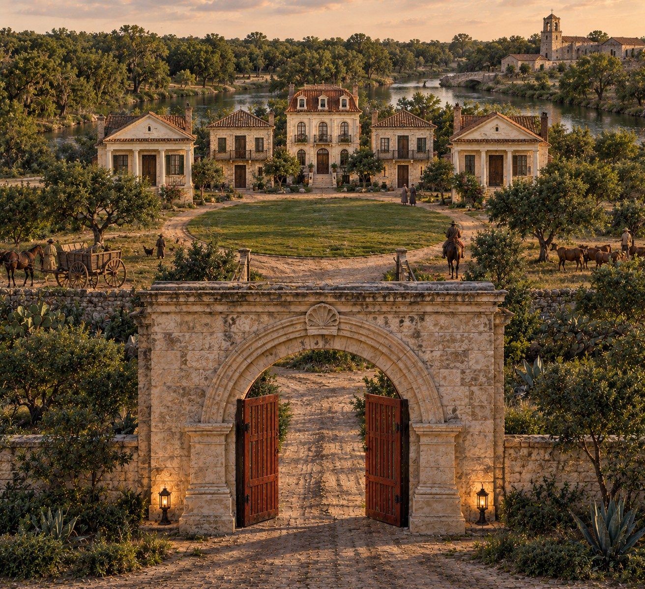
Illustrated reconstruction
1718Proposed
The land, 1714–2026
The same ground, three centuries
How to read this
Scroll down the river, one era at a time, from 1714 to today.
The picture is the land in that era. Below it: what stood there, and who decided what came next.
The counter on the picture adds up public money as you scroll. Spent is money already paid out, in today’s dollars. Committed is approved but not yet spent, like the $60M buyback and the roughly $800M arena share, and it’s shown separately.
marks where my family enters the record.
Public money into this ground, so far$0spent, in today’s dollars+ $860M committed
Illustrated reconstruction
1714
The land
Brush country along the San Antonio River. In 1718, Mission San Antonio de Valero is founded near the river’s headwaters. It reaches its present site in 1724.
The decision
The Spanish Crown decides where the missions and presidios go, and who gets the land around them.
My line enters the record here: Francisco Hernández, alférez (ensign), enlisted in 1717 “with his family” and on the garrison’s first roll, June 14, 1718. The church records that follow make him, almost certainly, mine.
1731
The land
The villa of San Fernando de Béxar takes shape between the river and San Pedro Creek, around Main Plaza.
The decision
The Crown brings Canary Island families and gives them most of the titles and land: town lots, farm plots, and the rank of hidalgo. They are credited as the city’s founders, though the presidio and the mission were already here.
The question
Who got the land?
Mostly the Canary Islanders
The soldiers’ families and the mission already at Béxar did the founding. The newcomers got the titles, the lots and the credit.
1837–1841
The decision
Under the Republic of Texas, San Antonio is chartered as a city in January 1837. Land, records and power pass to a new government.
In 1841, Thomas Addicks is elected county clerk at Béxar: my family keeping the kind of records this site is built on.
1850s–1900s
The land
Germantown forms south and east of downtown: families of German, Alsatian, Mexican, Polish and African American ancestry, in houses from 1850s caliche cottages to Victorian mansions.
The decision
German speakers outnumber both Tejanos and Anglos in the city until after 1877. The neighborhood grows for a century on its own.
1949–1955
The land
Germantown is still a neighborhood. On the east side, Bexar County opens its Coliseum in 1949.
The decision
1951: a new city charter hands day-to-day power to an appointed city manager; the mayor keeps one vote of eleven. From 1955, the Good Government League recruits and funds the council for twenty years in the name of “growth, expansion, and economic development.”
1964
The land
569 structures, 593 households, about 1,600 people on 140 acres. The agency’s own engineers rate 169 buildings sound or fixable.
The decision
March 12: the council declares the land “needed for convention center.” May 7: it approves surveys to see whether the area “may qualify” as blighted. August 27: it finds it blighted. Every vote unanimous.
The money
$46M$433M today $11M in city bonds (1964), up to $18.6M in federal grants (1966–73) and a $16.4M city share (1967).Ords. 32165, 32179, 32291, 32292, 32738, 34068, 35345, 42746
The question
Who decided, and who was moved?
Owners only
Only property owners could vote on the 1964 bonds. Three of every four households rented. Relocation money was capped at about $850 a person.
1966–1968
The land
Germantown is cleared. An architect proposed saving 120 historic buildings; 22 survive.
The decision
The city buys 15.813 cleared acres from its own agency for $401,842.54. Then it pays $334,059 for 13 more acres and deeds them to the State.
The money
$334,059 $165,797.45 (1966) plus $168,261.14 (1969) from the general fund, for land handed to the State. Not added to the total, since part may sit inside the 1967 city share.Ords. 34989, 35199, 37347, 45054
The question
Who got the land the city paid for?
The State, free
In exchange for a promise to put up a building: the Institute of Texan Cultures.
1968
The land
HemisFair ’68 opens on the cleared ground: the Tower of the Americas, an arena, the Institute, a convention center.
The decision
The Tower is paid for with $5.5M from the city’s general fund. The fair runs April 6 to October 6.
The money
$23M$207M today $5.5M for the Tower from the city’s general fund, $10M for the Texas Pavilion from the State, $7.5M for the U.S. Pavilion from Washington.Handbook of Texas, “HemisFair ’68”
The fair closes October 6, 1968.
What the ground becomes next is decided by the people who cleared it.
Part II · The ground in play, 1973–now
Public money into this ground, so far$0spent, in today’s dollars+ $860M committed
Illustrated reconstruction
1973–1988
The land
The Spurs make HemisFair Arena home.
The decision
1988: the police contract gets an “evergreen” clause that keeps the old deal running when no new one is reached. A 2014 lawsuit to remove it fails.
HemisFair Arena, 27 years old, is torn down so the convention center can grow.
2001–2022
The land
The convention center expands onto the old arena site in 2001 ($215M), and again in 2016 ($325M).
The decision
The bond machine: $550M in 2007, $596M in 2012, $850M in 2017, $1.2B in 2022. Every five years, bigger than the last.
The money
$540M + $112M + $30M$806M + $136M + $32M today $215M (2001) and $325M (2016) to expand the convention center, in bonds backed by hotel tax. Then $112M to rebuild Hemisfair: $30M (2012 bond), $36.9M (2017), $39.8M (2022), and $5.4M in Tower repairs. And $30M in 2022 for convention center escalators, elevators and building systems. Refinancings of the old convention center debt are not counted again.City ACFRs; San Antonio Current (2012); city bond program data; KSAT (Dec. 2024)
2026
The land
The Institute of Texan Cultures comes down. The city buys the ground back for $60M.
The decision
About $800 million in public money is committed to a new Spurs arena on it.
The money
$860M committednot yet spent The $60M buyback and the ~$800M public share of the arena: the city up to $489M, Bexar County up to $311M.KSAT (Sept. 11, 2026); San Antonio Express-News (Sept. 30, 2026)
2030 Projected
The land
If it’s built: a new Spurs arena opens on the Institute of Texan Cultures site, inside the 1964 line. The Spurs’ goal is July 2030; the city’s 2025 timeline said 2032.
The money
$2.47Bon this ground, if built $1.61B already spent, plus $60M for the buyback and up to $800M for the arena: the city up to $489M, Bexar County up to $311M.Interest on the new debt is not included, so this is a floor. Spent figures in today’s dollars; committed figures as announced in 2025–26.
I chose a family name and found eleven generations on this river. This is what happened to the ground while they were here.
Sixty years, $1.61 billion and counting, one parcel of land.
Sources: City of San Antonio ordinances and council minutes (Municipal Archives); Urban Renewal Agency, Format for Public Hearing (1964); Handbook of Texas, “HemisFair ’68” and “San Antonio, TX”; the family record on The Story. Images are illustrated reconstructions, not photographs.
Now check it on the real ground: the 1964 line, the parcels, and the records behind them.
140.3acres
569structures
593households
~1,600people
The ground, 1964 to today: an interactive map
Ground
Government
Development
1964 · agency planToday
Tap a year. Tap anything on the map to see the record behind it.
Streets, parcels, historic districts and parks: City of San Antonio open GIS and Bexar Appraisal District (2026). River: U.S. Geological Survey, National Hydrography Dataset. The 1964 line is traced from the Urban Renewal Agency’s July 1964 boundary plan (R-213) and drawn on today’s streets; the plan itself is overlaid as a document, aligned to surviving intersections to within about 15 meters. The map begins in 1964, with the Urban Renewal Agency’s boundary plan. For the ground before 1964, see the slider above. Owners are named only for public bodies. The 1964 figures come from the Urban Renewal Agency record and City ordinances.
Part I
The Ground
In 1964 the city drew a line around 140.3 acres and called it “for the use of the general public.”
Century after century, San Antonio's leaders have shown us how they choose to use the assets of the land this city was founded on.
The buildings change. The governments change. The names change. The ground remains. This investigation follows what happens when the city acquires it, clears it, finances it, redevelops it, gives it away, builds on it — and decides what comes next.
THE LANDWhat the city controls, acquires or clears.
THE DECISIONWhat leaders decide the ground is for.
THE MONEYWho finances the transformation.
THE AFTERLIFEWhat happens when the next generation arrives.
The parcel
This is the ground. 140.3 acres, downtown San Antonio.
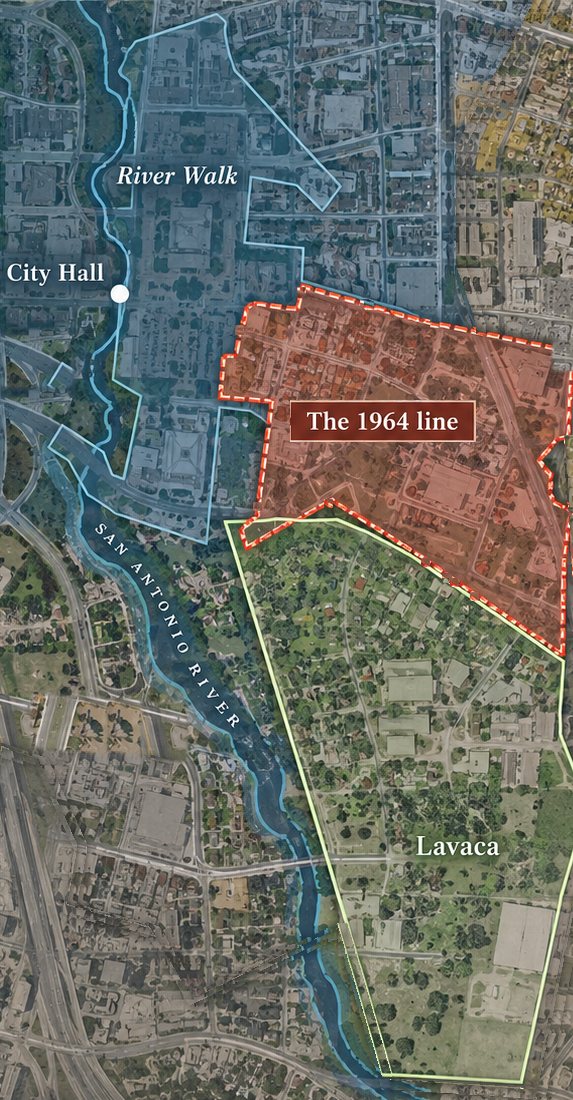
The whole city. The box is the view at right.The 1964 line Lavaca, next door, never cleared The river corridor Illustrated aerial, not to scale.
Urban Renewal Project V, Tex. R-83: 140.3 acres southeast of downtown, roughly from Market Street south toward Durango and from South Alamo east to the I-37 line. Designated “as needed for convention center and other municipal purposes” by Ordinance 32291, May 7, 1964. Today it holds Hemisfair, the Tower of the Americas, the convention center and the old Institute of Texan Cultures site.
The money, year in, year out
The river timeline counts what went in. This is what the ground costs and returns every year, next to the neighborhood that was never cleared.
$1.61 billion in public money spent on this ground since 1964, in today’s dollars. In fiscal 2025 it took in about $40 million less than it cost to run the convention center and pay its debt.
Open the ledger
The convention center, year by year
It has never brought in enough to cover its own debt payment.
What the convention center took in each year, next to what the city paid on its debt. That’s before paying anyone to run it.
Convention center incomeIts debt paymentEstimate
Running it costs more on top
The city budgets the convention center and the Alamodome together. Their operating costs ran $5.4M to $19.3M a year more than both venues brought in, every year from 2017 through 2026. Hotel-tax transfers covered most of it. In 2021–2024, $48.1M in federal pandemic money and $7.6M from the general fund went in too.
Where the annual reports split them out, the convention center alone cost $26.6M to run in 2018, $37.2M in 2024 and $39.1M in 2025.
Is this normal?
Partly. Big-city convention centers get a major project about every 11 years. San Antonio’s has averaged one every 9.6, among the most frequent of 28 cities I checked. Several Texas cities are now tearing theirs down to start over: Dallas for $3.8 billion, Austin for $1.6 billion.
Whether it pays is the open question. UTSA professor Heywood Sanders found that the city counted 336,966 convention attendees in 1989. After the 2001 expansion, consultants forecast 662,000. In 2019 it drew 365,850. The industry argues his data is too narrow. San Antonio is studying a sixth expansion.
Sources: opening and expansion years for 28 U.S. convention centers from city, venue and news records (my count; sources list projects unevenly, so the ranking is approximate). Heywood Sanders, “Space Available” (Brookings, 2005) and his San Antonio Current column of May 9, 2022, citing city and Arthur Andersen figures. Dallas: Dallas Morning News via NBC DFW, Sept. 2026. Austin: Conference & Meetings World, May 2025. Industry rebuttal: HVS, May 2005.
See the numbers
Fiscal year
Convention center income
Debt payment
Short
Venues’ gap (both)
Sources: City of San Antonio Adopted Budgets FY2019, 2021, 2023, 2024, 2025 and 2026 (Community & Visitor Facilities Fund; Convention Center Lease Payment Fund); annual financial reports for 2018, 2024 and 2025. Each budget reports actuals two years back; 2018, 2020 and 2025 are city estimates, and 2026 is the adopted budget.
The hotel next door
Public tax money stood behind a private hotel, and the city’s rent came last.
2005: $208.1 million in bonds through a city-created corporation built most of the 1,003-room Grand Hyatt on city land. The city backed them with hotel taxes, including its city-wide 2% expansion tax.
2008–2022: the city’s ground rent sat at the bottom of the bond payment order. No ground rent was paid; $4.86 million built up.
2020–2021: when the pandemic hit, the city paid $10.4 million in hotel taxes to cover the private hotel’s bond payments.
April 2022: Hyatt sold the hotel to CFC-SA, LLC, an Arizona nonprofit, financed by up to $450 million in bonds through a Wisconsin conduit issuer. The old bonds ($168.3 million) were paid off, the city got its $10.45 million and $4.86 million in back rent, and Hyatt got the rest. News reports put the price at about $140 million. Three council members abstained, citing the lack of transparency.
Now: the city no longer backs the debt, Hyatt runs the hotel under a 30-year contract, the parcel pays no property tax, and the city takes ownership when the 40-year bonds are paid off, around 2062.
Sources: City of San Antonio 2012 and 2022 official statements (FY2021 annual financial report, Note 22); Moody’s (May 2005); San Antonio Report (Feb. 23 and Mar. 11, 2022); Bexar Appraisal District.
The tower
The city kept the elevators, then paid Landry’s to take them.
2004: the city leases the Tower of the Americas to Landry’s for 15 years, with one 10-year renewal option. The city keeps the elevators.
June 2006: Landry’s reopens the Tower after a renovation city staff put at more than $15 million.
December 2006: the elevators start failing, mid-modernization.
May 17, 2007: council hands the elevators to Landry’s and pays for it in rent credits of up to about $9.1 million, including $3 million toward Landry’s renovation. Contingencies of 15 to 30 percent are built into the estimates.
2007–2013: base rent was $984,375 a year. The scheduled credits came to nearly all of it. The city also dropped its late-opening charges against Landry’s.
Now: Landry’s still runs the Tower, under a contract from January 2025 to September 2031 with a minimum guarantee of $984,000 a year. In fiscal 2025 the city booked $1.08 million from it.
Sources: City of San Antonio Ord. 2007-05-17-0570, First Amendment to Lease and Development Agreement, and staff memo (May 2007); City of San Antonio FY2025 Annual Comprehensive Financial Report, p. 256.
Two neighborhoods, almost the same size. One costs the public every year. One pays in.
The ground cleared in 1964
140 acres · convention center, Hemisfair, the Tower
−$40M
every year
Costs the public
$69.3M
running the convention center
$39.1M
paying off its debt
$30.2M
Brings back
$29.4M
convention center income, Tower and hotel rent, antenna leases, property tax on one hotel
Lavaca, next door
138 acres · never cleared · 437 homes
+$6.8M
every year
Costs the public
no project budget
one $250,000 park, 2022 bond
Pays in, property taxes
~$6.8M
to the city
~$1.6M
to schools, county, hospital, college and river districts
~$5.2M
Fiscal 2025, the latest full year, from the city’s budget and annual financial report. Lavaca’s taxes are its appraised taxable value ($276M, Bexar Appraisal District) at this year’s rates, before homestead exemptions, so actual bills run somewhat lower. Neither side counts ordinary city services like police, fire and streets, which both get. Hotel taxes that visitors pay across the city are not counted as coming back, because they can’t be traced to this ground.
The evidencedates, votes, receipts, sources
THE PAPER
The cleared ground moved from the Urban Renewal Agency into the City's hands.
LEDGER LINE · CIVIC CENTER PROJECT, TEX. R-83
The Urban Renewal Agency had assembled and cleared the property for the Civic Center project. In January 1966, it conveyed 15.813 acres to the City of San Antonio for $401,842.54. The City paid for that land with proceeds from the 1964 convention-center bonds, and the same ordinance accepted the deed and approved the redevelopment agreement that governed what came next.
1964Urban Renewal PlanCity-approved plan for the Civic Center Project, Tex. R-83.
Jan. 13Agency authorizes sale15.813 acres to the City for $401,842.54, subject to federal concurrence.
Jan. 27Ordinance 34068City accepts the deed and appropriates the purchase price from 1964 bonds.
1966RedevelopmentThe agreement describes clearance, removal of existing improvements, grading and preparation for the public-body project.
15.813acres conveyed
$401,842.54purchase consideration
1964bond fund used for purchase
Source: City of San Antonio Municipal Archives, Ordinance 34068 (Jan. 27, 1966); Urban Renewal Agency resolution authorizing the sale (Jan. 13, 1966); Contract for Sale of Land for Redevelopment by Public Body. The record itself is the exhibit; no later title conclusion is implied here.
The land the city gave away
Paid for. Given away. Bought back.
1966The city pays $165,797.45 out of its general fund for 6.524 acres of the cleared land. Ord. 34989
1967It deeds that land to the State of Texas for nothing. The only payment is “the agreement by the State of Texas to erect certain improvements.” It leases the State 6.527 more acres and promises to convey them “without cost.” Total: 13.051 acres, for the Texas State Exhibits Building, later the Institute of Texan Cultures. Ords. 34989, 35199
The condition (unverified)If the State stops using the land for that building or other State attractions, and doesn’t fix it within six months of notice, title “shall revert” to the city. The second tract was to be deeded on the same form. Ords. 34989, 35199
1969To deliver the second tract, the city pays again: $168,261.14 moved out of the general fund’s contingency account to the Urban Renewal Agency for 6.544 acres, then deeded to the State. The assistant city manager’s reason, on the record: “to live up to the agreement with the State of Texas for this land.” Passed 8–0. Ord. 37347; council minutes, March 20, 1969
1975The city hands the University of Texas System another 1.638 acres next to the building, in exchange for 0.135 acres. Ord. 45054
2026With UTSA moving the museum out of the building, the city approves $60 million ($115.7M with financing) to buy the site, about 13.5 acres, back from UT. By the end of September the building is coming down.
$334,059the city paid for the land it gave away, 1966 and 1969 (about $3M today)
$25,500per acre, both times (about $247,000 in today’s dollars)
$4.4Mper acre to buy the same land back in 2026: $60 million for about 13.5 acres
Not verified
The condition above is what the 1966 and 1967 deeds say. Whether it was still attached when the land passed to the University of Texas has not been verified. The recorded 1969 deed for the second tract (Ord. 37347), a later deed, or the law that moved the Institute to UT could have released it. Until a title search or a real estate attorney confirms it either way, treat it as an open question, not a finding.
The people moved off the land mostly couldn’t vote on the bonds that cleared it.
Who could vote, Jan. 1964
Owners only
in the bond election
Only property owners could vote on the $11M in convention center and arena bonds.
Who lived on the land
76%
of households rented
449 of the 593 households were renters.
Those 449 renter households had no say at the ballot box.
Bond election rules: Texas State Historical Association, “HemisFair ’68.” Households: the Urban Renewal Agency’s own survey, Format for Public Hearing, 1964 (in the Ord. 32291 file).
The people vs. the ground
What the people who were moved got, and what the ground got after them.
Relocation money, per person
$850
at most
The federal relocation grant was capped at $1,353,400 for about 1,600 people.
A ceiling, not proof of what was paid.
Public money into the ground, per person moved
$1.0M
since 1964
$1.61 billion spent on the land since 1964, in today’s dollars, divided by the same 1,600 people.
Not counting the arena or the buyback, which are committed but not yet spent.
Relocation cap: Ord. 42746 (1973). Total: the receipts below. Figures in today’s dollars (CPI-U, 2024).
The debt vs. the income
In 2024 and 2025, the convention center’s debt payment was bigger than everything it took in.
What it takes in, a year
$26.5M
fiscal 2025
Every dollar of convention center revenue.
Fiscal 2024: $23.9M in, against $28.8M in debt payments.
What its debt costs, a year
$30.2M
fiscal 2025
Payments on the bonds that paid for the expansions.
$537M still owed (March 2026). Last payment: 2042. That is about 20 years of every dollar the center earns.
Revenue: fiscal 2026 adopted budget and FY2025 annual financial report. Debt: FY2024 annual financial report (bonds outstanding, final maturity) and the Lease Payment Fund (fiscal 2025 estimate). The debt is paid mostly from hotel taxes, not property taxes, but it is still public money.
Since 1964: $1.61B spent, in today’s dollars.See every receipt
One spot, the whole city
The square is all of San Antonio. The speck in the circle is the 1964 line, drawn to scale.
0.04%of the city’s land
3.7%of its 2017 and 2022 bond money ($76.6M of $2.05B)
Bond money per acre
Inside the 1964 line$549,000
Everywhere else$6,200
Nearly 90 times as much, per acre, as the rest of the city.
Count what’s been spent and this one spot carries about $11.5 million in public money per acre, in today’s dollars. Add the buyback and the arena and it’s about $17.6 million an acre.
For scale: the clearing displaced about 1,600 people. That is roughly $1 million in public money for every one of them, in today’s dollars, spent on the ground they were moved off of, before the arena.
Clear it1964–73
1964City bonds for a convention center and arena. Only property owners could vote.City bonds, voter-approved$11M$111M today
1966–73Federal urban renewal grants to buy and clear Germantown, and relocate the people living thereFederal grants$18.6M$168M today
1967The city’s share: three garages, a 25-acre park, a chilling plant, utilities, and buying the cleared landCity, incl. utility boards$16.4M$154M today
Build the fair1968
1968Tower of the Americas, from the city’s general fundCity general fund$5.5M$49.6M today
1968State of Texas: the Texas Pavilion, later the Institute of Texan CulturesState$10M$90.1M today
1968Federal: the U.S. PavilionFederal$7.5M$67.6M today
Expand it2001–16
2001Convention center expansion onto the old HemisFair Arena siteCity$215M$381M today
2016Convention center expansion, the largest capital project in the city’s historyCity, bonds backed by hotel tax$325M$425M today
2022Convention center improvements: escalators, elevators, mechanical and electrical, from the 2022 lease revenue bondsCity, bonds backed by hotel tax$30M$32M today
Rebuild it2012–23
2012Bond: Hemisfair parks, preservation and streetsCity bonds, voter-approved$30M$41M today
2017Bond projects inside the 1964 lineCity bonds, voter-approved$36.9M$47.2M today
2022Bond projects inside the 1964 lineCity bonds, voter-approved$39.8M$42.6M today
2021–23Tower of the Americas repairs, city money beyond the bondCity maintenance funds$5.4M$5.6M today
Buy it back2026–32
2026The ITC site, bought back from the University of Texas ($115.7M with financing). The city gave this land away in 1967. See below.Tax-increment (Midtown TIRZ) debt$60M
2025–32The arena’s public share: the city up to $489M and Bexar County up to $311M. Committed, not yet spent.County venue tax · state hotel taxes · Hemisfair tax zone · proposed~$800M
Spent, as spent$751M
Spent, in today’s dollars$1.61B
Committed, not yet spent~$860M
Amounts are nominal unless noted. Funding sources are labeled on each row: they come from different governments and different taxes, and are added together only to show the scale on one piece of ground. This is a selected public-investment ledger, not a complete accounting.
Next bond Hemisfair is already asking for $37.8M more. Not yet approved, not counted above. City staff also want $35M from the May 2027 bond for improvements around the arena site, down from up to $250M floated in 2025. If voters say no, the city manager says the arena deal gets “reexamined.”
The ledger
How the yearly numbers are counted
How this ledger is counted
Same boundary. Only money inside the 1964 line, going in or coming out.
Only real money. Appropriations, revenue collected, lease payments, sale prices. No “economic impact,” visitor-spending estimates or multipliers, from either side.
Gross and net. What a building earns, and what it costs to run.
Blanks stay blank. A missing number is marked missing, not estimated.
Published either way. If any piece earns more than it costs, it says so here.
The convention center, year by year
It has not covered its own operating costs in any year on record here, before a dollar of debt. From 2018 to 2025 its costs rose 47% while its revenue rose 25%.
2015In$14.3MCostnot reported separately—
2018In$21.2MCost$26.6M−$5.4M
2024In$23.9MCost$37.2M−$13.3M
2025In$26.5MCost$39.1M−$12.6M
2015, the last year before the expansion opened, is shown for revenue only: that year’s audit reports the convention center and Alamodome together. Debt payments on the expansion come on top of every year shown: $28.8M in 2024.
Hemisfair owes the city. In 2016 the city borrowed $18.1M for Hemisfair park improvements, to be repaid by the Hemisfair nonprofit out of rent from private development on its northwest corner. That development was delayed. Payments were deferred, $8.8M in missed payments and interest has built up, and repayment doesn’t resume until 2028. The balance runs through 2037.
Beyond hotel taxes. Most of the gap is covered by hotel taxes, which visitors largely pay and state law limits to tourism and convention uses. When those fell short, the city also moved $5.9M from its General Fund (2021) and $6.99M in federal COVID relief money (2024) into the fund that runs the convention center and the Alamodome.
Not counted yet: what the Hemisfair tax zone actually collects, the Hemisfair nonprofit’s lease income, property tax on private parcels inside the line, and convention center costs for the years not shown. None is likely to change which way this ledger points, and each will be added when it’s in hand.
Ledger sources
City of San Antonio Annual Comprehensive Financial Reports: FY2018 (Community and Visitor Facilities budget-and-actual schedule, “Total Convention Center”), FY2024 (same schedule; long-term debt table, Texas Public Facilities Corporation bonds), FY2025 (same schedule, p. 342; Tower of the Americas agreement, p. 256; Hemisfair interfund borrowing, p. 119; convention center revenue, introductory section). City of San Antonio FY2026 Adopted Budget (Hotel Occupancy Tax Fund, p. 262; Community and Visitor Facilities Fund, p. 264; Convention Center Lease Payment Fund, p. 267). City of San Antonio FY2021 Proposed Budget, Hotel Occupancy Tax Fund work session, Aug. 26, 2020 (revenue by year, slide 4; General Fund transfer, slide 10). City Council item 20-3442 (Tower antenna leases). Ordinance 42746 (1973), relocation grant. All amounts are nominal dollars for the year shown.
What’s counted, and sources
Public money from every level of government: city (including its utility boards), county, state and federal. Figures are before financing. “Today’s dollars” converts each year’s spending to 2024 dollars with the national consumer price index; money from 2024 on is shown as is. The federal figure is the maximum authorized in the 1973 agreement. The arena figure is approximate: about $311M county venue tax, $245M state hotel taxes through a city finance zone and $244M from the Hemisfair tax zone, under a term sheet that is non-binding until final agreements are signed. The 1967 city share leaves out the convention center and arena, so the 1964 bonds are not counted twice.
Not yet counted, so the total can only go up: the 1977 and 1986 convention center renovations, any 2007 bond money, Hemisfair tax zone spending, the city’s yearly funding for the Hemisfair nonprofit, rent the city paid on the fair site (about $347,000, 1966–69), the fair’s reported $7.5M loss, and the city’s two payments for the land it gave the State ($334,059, 1966 and 1969; the 1966 payment may already sit inside the 1967 city share).
City records (City of San Antonio Municipal Archives): Ordinance 32291 (May 7, 1964), the 140.3-acre boundary and map; Ordinance 34989 (Nov. 23, 1966), the ITC land purchase and deed to the State; Ordinance 35199 (Feb. 16, 1967), the second tract; Ordinance 35345 (April 20, 1967), the city’s share; Ordinance 41144 (1972), the land price cut; Ordinance 42746 (Sept. 6, 1973), the federal share; Ordinance 37347 (March 20, 1969; text and vote in that day’s council minutes), the second tract bought and deeded to the State; Ordinance 45054 (March 21, 1975), the exchange with the University of Texas System; Ordinances 31829 (Oct. 17, 1963), 32165 (March 12, 1964), 32179 (March 19, 1964) and 32292 (May 7, 1964), the boundary changes.
Who holds the power over this ground, and who chose them.
9 of 9
Pick a piece. Follow the address. Check the record.
San Antonio’s ten council districts
Pick a piece. Then follow the address.
Every piece is an institution, and its position is geographic, not symbolic. Select one to open its record. The full roster below shows the institution and its stated authority in one place.
ElectedAppointedPrivate / contracted
Explore it — or let the record walk you through
The map is the geographic view; the roster is the record view. Pick a question above the map, or tap any piece on it. “Walk me through it” takes you through the record one step at a time.
Selected pieceNone — choose a marker
2 of 9
answer to voters.
MayorElected
City CouncilElected
City managerHired
CPS EnergyAppointed board
VIAAppointed board
SAWSAppointed board
HPARCAppointed board
Police unionPrivate
SpursPrivate
And 6 of the 9 have their offices in one council district: District 1. Most of the people shaping this ground work inside a district that elects one of eleven council members.
Tap any district on the map to see who represents it, what it got, and which players sit there.
Ask the map
Your moneyWhat your district gets.
Who decidesWho controls the money and the ground.
The ground and the teamThe history.
Beyond San Antonio
Where else have the Spurs played?
Austin every season since 2023. Mexico City six times. Europe nine times, with Paris and Manchester next, in January 2027. The NBA counts those as the Spurs’ 10th and 11th games in Europe, broadcast to more than 200 countries and territories.
Austin · Moody CenterI-35 Series, every season since April 6, 2023. The first game set a Moody Center attendance record. Three Austin games in 2026–27: Rockets, Oct. 23; Grizzlies, Feb. 26; Nuggets, Feb. 28.
Manchester · Co-op LiveNext: Pelicans, Jan. 17, 2027. The NBA’s first regular-season game in Manchester, and the Spurs’ first game in England.
Paris · Accor ArenaPreseason: 2003, and two games in France in 2006. Regular season: Pacers, Jan. 23 and 25, 2025. Next: Pelicans, Jan. 14, 2027.
Milan (Assago)Exhibitions, October 1999: two games, against Varese and Vasco da Gama.
BerlinPreseason, Oct. 8, 2014: Alba Berlin.
IstanbulPreseason, Oct. 11, 2014: Fenerbahçe.
My read
The road is good for the brand. Every game the Spurs take to Austin, Mexico City or Paris puts San Antonio’s name in front of fans an arena on the East Side, or downtown, can’t reach. With a French star, Paris plays like a second home crowd. That reach comes from the team and the schedule, not from the building, which is worth remembering before the city pays for a new one.
Sources: NBA Communications, “Pelicans and Spurs to play regular-season games in Paris and Manchester in 2027” (May 2026); NBA Events, Paris Games 2025; Texas Public Radio, 2026–27 schedule (Aug. 13, 2026); KSAT (Apr. 7, 2023); Air Alamo, Spurs Global Games history. Ordinary road games are not shown.
N
approx. city scale
Walk the record1 of 8
Ask the map
ElectedAppointedPrivate or contracted
Public record layers
City of San Antonio open GIS data. Turn on a layer, then tap or hover a shape.
What these layers mean
Tax increment zones (TIRZ)
The city freezes the property-tax base inside a zone. As values rise, the extra tax stays in the zone to pay for projects there instead of going into the city’s general budget. Hemisfair is zone #34.
Opportunity Zones
A federal tax break created in 2017. Investors who put capital gains into designated low-income census tracts can delay and cut the tax they owe on those gains.
Bond projects
Every five years, voters approve the city borrowing money for streets, drainage, parks and buildings, repaid from property taxes. Tap any dot for its cost and status.
No layer on
Seven layers, all from the city’s own records.
Start with TIRZ (tax increment zones, where new property-tax growth is kept for projects inside the line) or bond projects to see where public money is pointed.
Pan the map → select a marked place
Every player on the mapicon = record
District lines, Loop 410 and Loop 1604 come from the city’s own GIS data. Each piece sits at its real address, except SAWS, moved slightly so it doesn’t cover the police union. The six downtown offices are too close together to tap here; use the names under the map.
Downtown close-up, not to scale: the six offices inside the dashed circle above, nudged apart enough to click, each still on its true compass bearing from Main Plaza. All in Council District 1 (Sukh Kaur).
Power on paper
≠
Power in practice
Where have the Spurs played and trained?
Three arenas, and a fourth planned back on the ground cleared in 1964. Illustrated reconstruction, not to scale.
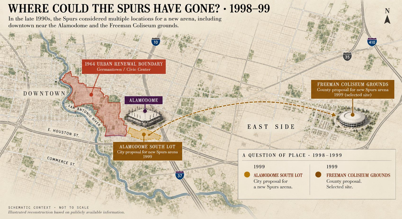
1999 · THE QUESTION OF PLACE
Two offers, one arena
The new arena was not inevitable in its eventual location. The Spurs and the city had reached a deal for an arena next to the Alamodome, including its south parking lot. At the same time, Bexar County was advancing a proposal for an arena next to Freeman Coliseum.
In a last-minute reversal, the Spurs went with the county. In August 1999, the county, the Spurs and the livestock show signed a letter of intent for a $175 million arena next to Freeman, paid for by raising the county’s hotel tax 1.75 points and its car-rental tax 5 points. Voters approved it that November.
Sources: The Battalion (Associated Press), Aug. 25, 1999; Frost Bank Center history.
Two sites on the table in 1999. Illustrated reconstruction · schematic, not to scale.
The full roster: nine playerswho they are, what they can do, who they answer to
The roster
Open one to see which ledgers name it.
Stay on the record
Get Notified
One email when something new goes up. Nothing else in between.
The same pattern every time: a public purpose, public money, a new purpose, more public money.
Where the ground went
Given away
Then the city gave the ground away. It paid $334,059 to the city’s Urban Renewal Agency, whose board the council appointed, for 13 acres the agency had taken from Germantown, and deeded them to the State of Texas for a promise: the Texas State Exhibits Building, later the Institute of Texan Cultures. It built the Tower, then paid Landry’s to run it: from 2007 to 2013, up to $9.1 million in rent credits covered nearly all of its roughly $1 million yearly rent. Landry’s still holds it, on a contract that runs to 2031. The Grand Hyatt sits on city land, pays no property tax on its parcel, and paid the city no ground rent from 2008 to 2022. Neither do 19 of the 20 parcels in the Hemisfair district, or the convention center.
Still paying
And the public keeps paying. In fiscal 2025, the ground generated about $40 million less than the documented costs of operating the convention center and servicing its debt. Separately, about $800 million in public money is committed to a new Spurs arena on the Institute of Texan Cultures site, within the former 1964 project area.
This part tracks it deal by deal: who held the power in the room, what they promised against what they delivered, and the rules that would make the next deal different. Better people won’t break the pattern on their own. Different rules will. Sourced and laid out so it can be checked.
Don’t take my word for it. A news story asks you to trust the reporter; this hands you the documents. Each ledger follows a single deal through the public record.
The next deal is being pulled from the record now. Want to know when it posts? Subscribe on Substack.
Nothing yet names this one directly. Check back as the record grows.
Sources and open items
City of San Antonio ordinances 31829, 32067, 32165, 32179, 32291, 32292, 32738, 34068, 34989, 35199, 35345, 37347, 41144, 42746, 45054 (Municipal Archive); council minutes, March 20, 1969.
Urban Renewal Agency, "Format for Public Hearing," in the Ord. 32291 file.
City of San Antonio ACFRs FY2024 and FY2025; FY2026 adopted budget; city bond program data.
Handbook of Texas; San Antonio Current (2012); San Antonio Report (2024, Jan 2026); KSAT (Dec 2024, Oct 2025, Sept 11, 2026); hemisfair.org history.
Bexar Appraisal District current roll, pulled Sept 30, 2026.
Car access and income by council district: U.S. Census Bureau, American Community Survey 2020–2024 5-year estimates (B25044, B08301, B19001, B17021), block groups split across the 2023 council districts by area. Project Marvel parking and the I-37 land bridge: Texas Public Radio (Nov. 21, 2024); San Antonio Report (2026). VIA capital plan: KSAT (Oct. 8, 2026). VIA Green and Silver Line routes and dates: VIA (keepsamoving.com FAQ; Silver Line exhibits, Aug. 2026); transit reach measured from Census block group centers. Hemisfair: HPARC board minutes (Sept. 13, 2024; July 9, 2025); hemisfair.org rental and event pages; San Antonio Current (Oct. 2026); Axios San Antonio (Sept. 27, 2023).
River section money: the $1.61 billion is spent money since 1964, in 2024 dollars (CPI-U); each era shows both the dollars of the year and today’s dollars.
Handbook of Texas, “HemisFair ’68” (fair theme; Germantown’s German, Mexican and African American settlers); Texas Public Radio, “What Came Before: The Demolished Neighborhood That Made Way For HemisFair ’68” (2018) (Latino, German and African American residents; over 1,600 people displaced).
Bexar County Clerk, Official Public Records (free online, bexar.tx.publicsearch.us): index of Urban Renewal Agency instruments, 1964–68; Notice of Lis Pendens, Urban Renewal Agency of the City of San Antonio v. M. F. Dausin, et al., Civic Center Project Tex. R-83, parcel 130, filed April 26, 1965 (doc. 653515).
Cipriano v. City of Houma, 395 U.S. 701 (1969), and City of Phoenix v. Kolodziejski, 399 U.S. 204 (1970): property-owner-only bond elections struck down under the Equal Protection Clause.
Not yet in the ledger: Alamodome and Frost Bank Center public costs; 1977 and 1986 convention center renovations; who covered the fair's $7.5M loss; whether the ITC reversion clause survived the transfer to UT (needs a title search).
How this site was made
I built Gatekeep San Antonio with an AI assistant, Claude, made by Anthropic. The research and the argument are mine. I followed my family through the archives, pulled the ordinances, deed records, bond data and council votes, and decided what this site says and why it matters.
Claude wrote the website’s code, built the interactive maps, processed the public data (Census figures, the city’s bond records, the county deed index), ran the numbers and checked facts against the sources. Where a figure is an estimate or a reconstruction, the site says so.
The writing. I brought a very rough first draft. Claude cut away what I didn’t need, and we went back and forth from there. Most of the time, what I typed back was better than what it sent me, and that back-and-forth is what sharpened this. In the end, it’s my voice. When a claim is my interpretation and not a documented fact, I label it that way.
The pictures labeled “illustrated reconstruction” were made with AI image tools. They are not photographs. For much of this ground and these years, no photograph I can use exists yet, so in the meantime the illustrations stand in. Where an AI illustration can be replaced with a real archival photograph, it will be.
Every figure traces back to a public record you can check yourself. If you find a mistake, email gatekeepsanantonio@proton.me or message me on Substack, and I’ll fix it.
The Ethical Wall
Part III · about 20 min read
The study the city called “independent” traces back to the Spurs’ own ownership group in four steps.
The ledger
When
What the public put in
What it got
Who decided
Receipt
2025
$330,665 for a study of the arena district
A report outside experts called “useless,” from a firm four steps from Spurs ownership
City of San Antonio
City contract; KSAT, Aug. 15 and Oct. 1, 2025
Aug. 21, 2025
The independent study council could have required
Nothing: the requirement failed, 4–7
City Council
Agenda Item 4, Aug. 21, 2025
Aug. 21, 2025
Up to $489M in city money
A $1.3B arena at Hemisfair, on terms not yet binding
City Council, 7–4, same session
City–Spurs term sheet
Under Construction
Part III · about 15 min read
Two streets from the same 2017 bond ran years late and millions over budget.
The ledger
When
What the public put in
What it got
Who decided
Receipt
2017
$42M in bond money for the Broadway Corridor
A promised four-lane street with bike lanes, sidewalks and shade
Voters, on a bond council put on the ballot
2017 bond program
2018–21
$20.8M in design work ($17.8M lower, $3M upper Broadway)
Plans for a street the state later took back
City of San Antonio
City disclosure; San Antonio Report
Jan. 27, 2022
The 2.2-mile transfer of Broadway
Nothing: the state kept the road and never paid its promised $5M
Texas Transportation Commission
Commission agenda, Jan. 27, 2022
2017–23
About $7M budgeted for North St. Mary’s Street
A street that cost $15.1M in all, finished a year past its contract deadline
City of San Antonio
Bond program; city bond dashboard, Oct. 2026
The Arena Cycle
Part III · about 15 min read
Four arenas in fifty-seven years: twice the Spurs paid 16 cents on the dollar, this time at least 38, and nobody has published a report card on the last deal.
The ledger
When
What the public put in
What it got
Who decided
Receipt
1989
A five-year half-cent sales tax (about $186M)
The Alamodome, which the Spurs left after nine years
Voters, 53% to 47%
City record; election reporting
1999–2002
$146.5M in county hotel and rental-car taxes
The east side arena; the Spurs paid $28.5M (16%)
Bexar County voters
Fitch Ratings, Oct. 2000
2015
$85M from the 2008 visitor-tax program
Its renovation; the Spurs paid $16.5M (16%)
Bexar County
Bexar County, 2015
2025
Up to $800M: city up to $489M, county up to $311M
A $1.3B Hemisfair arena; the Spurs pay at least $500M (38%)
City Council, with no public vote on its share; county voters, 52% to 48%
Term sheet; election results
My read
The leverage flipped.
The Spurs and this city found each other in a moment of mutual need. In 1973 a group of local investors brought the struggling Dallas Chaparrals down I-35 and into HemisFair Arena. The team had no leverage, and it was treated accordingly. The fans showed up anyway, before the championships, and this fan base is still one of the most loyal in the league.
Fifty years later the team has all the leverage. Its ownership group includes some of the wealthiest people in the country, and it is asking the public for about $800 million toward a new arena. The city’s $489 million share never went to a ballot. When Mayor Jones asked about revenue sharing, the term sheet answered in capital letters: “NO REVENUE SHARING.” The public carries the cost of the building, and the team keeps what it earns.
Who is the plan built for? The first arena plan asked for 10,000 more parking spaces in a city where 42,704 households have no car. Michael Dell, an Austin billionaire, joined the ownership group in 2021, and the team has played regular-season games in Austin every season since 2023. That is timing, not proof of motive. I can’t prove who the plan is meant to leave out. I can show who it works for.
This doesn’t have to be one-sided. It can be done so both sides walk away taken care of: a public vote on the city’s share, a lease as long as the bonds, clawbacks, cheap seats in the lease, and a district that stays public and reachable. The demands are in Part IV.
Sources: KSAT, “A look at San Antonio City Council’s rocky negotiations for new Spurs arena,” Aug. 21, 2025 (term sheet: “NO REVENUE SHARING”; Spurs “aren’t open to it under the current structure”; approved 7–4); KSAT, June 18, 2021 (Dell joins investor group); Texas Monthly (Austin games since 2023); Census ACS 2020–2024 (households with no car); arena figures as cited elsewhere on this site.
Freeman Coliseum
Part III · about 8 min read
A 1949 law set this ground aside for livestock shows. Then it got an NBA arena, and now it’s being remade again. Who decided it could change?
The ledger
When
What the public put in
What it got
Who decided
Receipt
1949
Buildings and grounds costing “more than two million Dollars” in public money
A coliseum bound by covenants for agricultural and livestock exhibitions
Texas Legislature; City of San Antonio to Bexar County
Acts 1949, 51st Leg., Ch. 119
1999–2002
County hotel and rental-car taxes
An NBA arena beside ground set aside for livestock shows
Bexar County voters
Contemporary reporting; Fitch Ratings, Oct. 2000
Nov. 4, 2025
$192M (Prop A)
Rebuilt rodeo grounds; no public legal review of the 1949 covenants found
Bexar County voters
TPR, May 27, 2025; CultureMap
Part III · Working title
The Audition
San Antonio is older than the country. It keeps paying to be picked anyway: by a world’s fair, the NFL, the NBA and the convention trade. Meanwhile the bonds residents vote for themselves run late.
SpentDeliveredCommitted, not spentProposed
Spent to be picked
Voted for ourselves
Read it right
The two lanes are never added together. A building cost, a county share, a cap and a bond authorization are different kinds of numbers.
Bars and totals are in 2024 dollars (CPI-U), the same basis as the site’s main tally. Tap any line for the amount at the time, who decided and the receipt.
Committed and proposed money is drawn but left out of the totals.
The Alamodome: the city hoped it would land an NFL team. Whether voters were promised one is disputed.
Left out until the record is clear: who covered HemisFair’s reported $7.5M loss; the ~$25M borrowed in 2004 for the convention center complex; the $10.4M the city covered for the Grand Hyatt in 2020–21, which was repaid.
Delivery records for the 2007, 2012 and 2017 bonds haven’t been pulled yet, so those bars show what voters approved, not what was built.
Sources: Ords. 32067, 32291, 35345, 42746; Handbook of Texas, “HemisFair ’68”; San Antonio Current (Sept. 2006); Big City Small Town (Aug. 30, 2025); Fitch Ratings (Oct. 2000); San Antonio Business Journal (Dec. 1998); SA Current (2012); 2012 and 2022 convention center official statements; Bexar County (2015); City–Spurs term sheet (Aug. 2025); Bexar County election results (Nov. 2025); KSAT (Sept. 11, 2026); City Capital Delivery bond dashboard (Sept. 1, 2026); Express-News (Sept. 30, 2026); BLS CPI-U.
Part III · Filed Oct. 2026
Who Pays to Pass It
The campaigns asking voters for public money are paid for by a few. Many of those few do the work once it passes.
The 2022 bond
$782,025 to pass $1.2 billion
Build SA PAC ran the yes campaign for the May 2022 bond. It took in 121 contributions. About a third of the money, roughly $262,000, came from about 40 firms that design or build public works: engineers, contractors and architects.
Contributor
Gave
San Antonio Chamber of Commerce
$137,000
Heriberto Guerra
$30,000
H-E-B, USAA, NuStar Logistics, Gordon Hartman Enterprises, Embrey Partners, John Nau, Eugene Dawson
$25,000 each
Joeris General Contractors, S&B Infrastructure
$25,000 each
E-Z Bel Construction
$15,000
Graham Weston
$15,000
Zachry Corporation and Zachry Enterprise Solutions
$20,000
Sundt, HDR, Michael Baker, Pape-Dawson, Halff, Raba Kistner, Vickrey & Associates, Quiddity Engineering, KCI, CivilTech Engineering, Ardurra
$10,000 each
Landry’s Management (runs the Tower of the Americas)
$5,000
Shaded rows: firms that design or build public works.
Two of the builders
E-Z Bel Construction
Gave $15,000 to the 2022 bond campaign on April 1, 2022. A year later the city brought it in as the second contractor on North St. Mary’s Street, a 2017-bond project.
That street had a $7 million bond budget. It has cost $15.1 million from all sources, and the city’s dashboard still calls it “On Schedule.” See Under Construction →
Sundt
Gave $10,000 to the 2022 bond campaign on May 9, 2022, while building two downtown street projects for the city.
South Alamo Street had $9 million authorized in the 2017 bond. The cost estimate rose from $36.6 million at the 2021 start to about $48 million. The Zona Cultural streets contract grew from $37.7 million by $2.7 million.
The arena vote, November 2025
More than $7 million against $219,000
Win Together PAC ran the yes campaign for county money toward the Spurs arena. By Oct. 25, 2025, it had reported more than $7 million: $5.3 million in checks from the Spurs and nearly $1.3 million in in-kind help, plus gifts from USAA, Valero, H-E-B, Zachry Corporation, Oxbow Development Group, Silver Ventures, Pearl Real Estate and Bartlett Cocke General Contractors.
The opposition, a PAC formed by COPS/Metro Alliance and funded mostly by member dues, reported $219,000. Prop B passed with just over 52%. At $7 million, that’s about $55 for every yes vote.
After the city’s vote
Six of seven
Seven council members voted yes on the arena terms on Aug. 21, 2025. In the spring of 2026, David Zachry, of the family that runs Zachry Corporation, gave $500 each to six of them: Sukh Kaur, Phyllis Viagrán, Marina Alderete Gavito, Ivalis Meza Gonzalez, Misty Spears and Marc Whyte.
Zachry companies and family members gave to city ballot campaigns in 2022 (the bond, $20,000), 2023 (San Antonio Safe PAC, $35,000), 2024 (Renew San Antonio, $35,000) and 2026 (the pre-K campaign, $25,000). In 2025 Zachry Corporation gave to the county arena campaign.
The status quo isn’t broken. It works for the few people who gain from it, and they have every reason to keep it that way.
Read it right
Every gift here is legal and public. These records show who takes part, and how much they put in. They don’t show a trade, and none is claimed.
Companies can’t give to candidates in Texas, but they can give to ballot campaigns. That’s why the big checks show up on bond and arena votes.
“Firms that design or build public works” is my sort, by company name, of the 2022 bond campaign’s contributors.
Peter J. Holt’s own gifts to council candidates were $500 to $1,000 (2021 and 2023). The Spurs’ money went through the arena campaign.
The city’s system keeps about five years of reports, so earlier campaigns aren’t here. The arena campaign filed with Bexar County; its final totals were due in January 2026 and aren’t reflected above.
Sources: City of San Antonio campaign finance filings (Build SA PAC, 2022; candidate reports, 2021–2026; San Antonio Safe PAC, 2023; Renew San Antonio, 2024; Renew Pre-K 4 SA, 2026), webapp1.sanantonio.gov/campfinsearch; San Antonio Business Journal (Apr. 18, 2023); City Bond Project Dashboard, project 23-01600 (saved Oct. 25, 2026); San Antonio Report (June 14, 2025; Oct. 27, 2025; Nov. 2025); KSAT (Oct. 29, 2025); San Antonio Current and Community Impact (Aug. 21, 2025).
Part III · Filed Oct. 2026
Who Keeps the Money
The public owns this ground and carries its debt. Private operators run the businesses that earn on it. Here’s where the money goes.
Money made on the ground
Who gets it
What earns money here
Where it goes
The new Spurs arena
The Spurs keep all of the arena’s revenue, and hold the naming, advertising and broadcast rights. They pay the city $4 million a year in rent, rising 2% a year, about $160 million over 30 years.
New property taxes in the Hemisfair tax zone
Kept inside the zone. All of it currently pays for HPARC’s operations: about $663,000 in 2025 and $927,000 projected for 2026. Under the arena deal, it’s pledged to the arena bonds.
Hemisfair rentals, events and ground leases
To HPARC, a board of 13 appointed members. It doesn’t publish its rental rates. Lease payments meant to repay an $18.1 million city loan are deferred until 2028.
Grand Hyatt rooms and events
Hyatt runs the hotel under a 30-year contract on city land. The city gets about $0.5 million a year in ground rent. The hotel parcel pays no property tax.
Tower of the Americas
Landry’s runs it. The city got $1.08 million in 2025, against a guarantee of $984,000 a year.
The convention center
To the city, but it doesn’t cover itself: $26.5 million in revenue against $39.1 million in operating costs in 2025, before $32.4 million a year in debt payments.
Convention center debt
To bondholders: about $259 million in future interest, through 2042.
The only taxable parcel in Hemisfair
The Zachry Park Hotel, 222 S. Alamo, built in 2024 and valued at $40.6 million. The other 19 parcels in the district pay no property tax.
Shaded rows: private businesses earning on public ground or public deals.
Follow the arena dollar
The ground pays for the building the team earns from
The city’s share of the arena, up to $489 million, will be borrowed. Four things repay it: the Spurs’ rent, ground rent from the private buildings around the arena, the Hemisfair tax zone, and state hotel taxes from a special finance zone. The first three cover 52% of the payments; the hotel taxes cover 48%.
So the rent the Spurs pay doesn’t reach the city budget. It goes back into paying off the building they use. The tax growth on this ground does the same. The Spurs keep the tickets, suites, concessions, naming rights and broadcasts.
The ground makes money. The public’s share goes back into paying for the ground.
Read it right
The arena terms come from the nonbinding term sheet approved Aug. 21, 2025. Final agreements are being negotiated in private, targeted for the end of December 2026, and could change.
The Spurs also commit at least $500 million toward the arena plus any overruns, $30 million toward the federal property next door, and $2.5 million a year for 30 years in community benefits.
Still missing: HPARC’s lease and event income (a records request is drafted), the tax zone’s collections before 2025, and current Grand Hyatt ground rent actually received.
Sources: City–Spurs Sports & Entertainment District Term Sheet (Aug. 2025); Texas Public Radio (Aug. 21, 2025); City TIRZ budget briefings (Sept. 3, 2025; Sept. 1, 2026); City FY2025 annual financial report (Tower, Hemisfair loan) and FY2024 report (convention center debt); FY2026 adopted budget (Hyatt ground rent; convention center debt service); Bexar Appraisal District (Hemisfair district parcels, pulled Sept. 30, 2026).
Part IV
What’s Next
What council should demand before voters decide the arena bond in May 2027.
Your district
How’s that bond working out for you?
San Antonio asks voters for a bond every five years. The next one is expected in May 2027. Pick your district and see what the last two promised, next to what the city’s own records say happened.
Report card
The city pays its debts. It doesn’t deliver on time.
Subject
What I measured
Result
Grade
Paying its debts
Credit ratings: S&P, Moody’s, Fitch
AAA / Aaa / AA+
A
2017 bond: finished on time
Projects completed by 2022, the end of its five-year window
115 of 177 (65%)
D
2017 bond: telling the truth
Of 58 projects that ran past the window, how many the city still calls “On Schedule”
55 of 58
F
2017 bond: stayed in budget
Bond money spent within 2% of the bond budget
170 of 177 (96%)
A*
2022 bond: on track
Projects scheduled to finish by 2027
134 of 187 (72%)
C
2022 bond: delivered so far
Bond dollars in finished projects, with about four of five years gone
17%
F
2022 bond: telling the truth
Of 49 projects already scheduled past 2027, how many are labeled “On Schedule”
36 of 49
F
*The bond amount is a cap; overruns get paid with other money. North St. Mary’s stayed “in budget” on its $7 million of bond money while costing $15.1 million in all. The dashboard’s total-budget field is too unreliable to grade full cost, so this A really means incomplete.
How it’s graded: 90% or better is an A, 80% a B, 70% a C, 60% a D, below 60% an F. The five-year windows are how the city sells each bond (2017–2022, 2022–2027). “On Schedule” may mean a revised schedule; the city doesn’t say. Counts are from the city’s Bond Project Dashboard, saved Oct. 25, 2026; the scale and grades are mine. Ratings as reported in August 2025: S&P AAA and Moody’s Aaa, both top marks, and Fitch AA+.
By district
Every district fails the honesty test.
District
2017 bond, finished on time
2022 bond, on track
Late projects labeled honestly
2017 bond, in budget*
2022 bond dollars delivered
District 1
F
11 of 28
C
17 of 22
F
2 of 21
A
26 of 28
35%
District 2
D
12 of 18
B
12 of 14
F
1 of 8
A
17 of 18
22%
District 3
D
15 of 22
B
17 of 20
F
2 of 10
A
22 of 22
14%
District 4
B
13 of 15
C
11 of 15
F
0 of 6
A
14 of 15
23%
District 5
F
8 of 14
D
11 of 17
F
2 of 10
A
14 of 14
24%
District 6
B
13 of 16
B
12 of 15
F
0 of 5
A
15 of 16
28%
District 7
B
12 of 14
B
13 of 15
F
1 of 4
A
14 of 14
11%
District 8
D
6 of 9
A
13 of 14
F
0 of 4
A
9 of 9
48%
District 9
B
9 of 11
D
9 of 14
F
0 of 7
A
11 of 11
21%
District 10
D
10 of 15
D
9 of 15
F
1 of 8
A
15 of 15
10%
Citywide projects
F
1 of 6
F
4 of 12
F
3 of 13
B
5 of 6
1%
Spanning districts
F
5 of 9
F
6 of 14
F
4 of 11
A
9 of 9
8%
Same scale and sources as the report card above. “Labeled honestly” combines both bonds: of the projects whose construction runs past their bond’s window, how many the city labels anything other than “On Schedule.” Some districts have only a few late projects, so the counts are shown beside every grade. The last column is the share of each district’s 2022 bond money in finished projects.
Scroll sideways. Projects behind schedule, over budget or cancelled come first.
Where this comes from. Every number is the City of San Antonio’s own, from its Bond Project Dashboard, saved on Oct. 25, 2026 (the dashboard was last updated Oct. 20, 2026). How I count it: “behind schedule” means the city labels a project “Off Schedule,” or labels it “On Schedule” while its construction runs past the end of its bond’s five-year window (2022 for the 2017 bond, 2027 for the 2022 bond). “Over budget” means bond spending more than 2% over the project’s bond budget. “Cancelled” is the city’s own label. The scope under “Promised” is the city’s own project description. “Spent, all sources” includes money from outside the bond, such as utility or partner funds. Years are calendar years from the city’s date fields. Found something wrong? Email me.
The museums
Built, renovated, torn down, rebuilt
Building
Opened
Since then
Convention center
1968
Expanded 1977, 1987, 1996, 2001 and 2016, with a $30M systems upgrade in 2022. A sixth expansion, proposed at about $900M, goes to council for a feasibility briefing Oct. 28, 2026. Is this normal? →
HemisFair Arena
1968
The Spurs played there 1973–93. Torn down in 1995, at 27 years old, for a convention center expansion.
Alamodome
1993
The Spurs left after nine years. $109M in upgrades through 2028, and the city is studying about $125M more over the next decade. An overhaul past $1 billion is pushed to about 2035.
County arena
2002
$101.5M renovation in 2015. The Spurs plan to leave by 2032, at about 30 years.
New Hemisfair arena
2030 (Spurs’ goal)
$1.3 billion, on the ground where HemisFair Arena came down.
Sources and full accounts are in the ledgers: The Arena Cycle, Ethical Wall, and the convention center records. The 2030 opening goal, the Oct. 28 briefing and the Alamodome study: San Antonio Business Journal, Oct. 22, 2026.
42,704 households in this city don’t have a car.
The first plan for the arena district asked for 10,000 more parking spaces and leaned on about $250 million in city bonds for a garage. That’s about what District 5 got from four bond programs in fifteen years: $246 million. One in seven households there has no car. The one piece that would have tied the East Side to the district, a land bridge over I-37, was shelved. The garage is still being studied.
Only about 1 in 10 of the city’s car-free households lives within a half mile of VIA’s two new rapid lines. The only east–west one was designed to run out to Frost Bank Center, the arena the Spurs are leaving.
If the district is for the city, why is the plan built for the people who drive in?
An independent economic study
The term sheet is non-binding until the final agreements are signed. Before then, a study that doesn’t trace back to the team’s own owners. See The Ethical Wall →
A public vote on the city’s share
Bexar County’s up to $311 million went to voters. The city’s up to $489 million never went to a ballot.
The land handed back to the people at no cost
Before paying $60 million for the old Institute of Texan Cultures site, settle whether the 1966 deed’s “shall revert” clause already returns it to the city.
Taxes, or payments in their place
On the arena and the entertainment district around it. Of the 25 parcels inside the 1964 line, 24 pay no property tax today.
Clawbacks
Public money comes back if the team leaves early or the promised district isn’t built.
Cheap seats, written into the lease
A block of low-price seats at every game. Cheap obstructed-view seats made the old arena everybody’s building.
The district stays public, and reachable
Plazas and parks built with bond money around the arena stay open on game nights and event days, with published rules for when and how much can be fenced. Hemisfair already closes parts of its bond-built lawn for ticketed festivals, under rates and terms it doesn’t publish. And a way to get there without a car: transit service on event nights, planned before the parking.
A lease as long as the bonds
No new arena while this one is still being paid for. HemisFair Arena came down after 27 years, and the debt on this ground runs to 2042.
No one pushed out
No displacement, and housing nearby that working San Antonians can afford. The last project on this ground moved about 1,600 people.
Daylight on the money around Hemisfair
Who funds the Hemisfair Conservancy, which gave HPARC $2 million for operating costs in 2024, and the terms of HPARC’s deals, before the bond money moves.
When to show up
Now
The Institute of Texan Cultures comes down
The building the State put up on the 13 acres the city gave away was torn down in 2025 (KSAT, Jan. 16, 2026). The Institute now operates from rented space in the Frost Tower downtown. The city paid $60 million to buy the land back.
Mid-October 2026
Council takes up the bond again
City staff have proposed a $442 million bond. Seven council members asked for $1 billion.
By early February 2027
Council has to call the bond election
Staff want $35 million of it for improvements around the arena site at Hemisfair, down from “up to $250 million” disclosed in 2025. HPARC, the nonprofit running Hemisfair, has asked for $37.8 million.
May 2027
The bond goes to voters
If voters reject it, the city manager has said the city would have to “reexamine the deal.”
July 2030
The Spurs’ goal for the new arena
The city’s 2025 timeline said 2032. On the old Institute of Texan Cultures site. Populous was named architect in May 2026; no final design had been released as of September 2026.
Every one of these is decided in public, by people who answer to voters or are appointed by people who do. That’s where the rules can change: who gets a seat at the table before the deal is made, not after.
Take this with you
Pick your district Not sure? Call 311.
Opens your print window. Choose ‘Save as PDF’ to keep a copy.
Read further
Heywood Sanders, UTSA professor and author of Convention Center Follies (2014). In the San Antonio Current he has tracked the convention center’s flat attendance and the Grand Hyatt sale. Read his May 2022 column →
Gene Morales, historian with a forthcoming book on HemisFair ’68. In November 2025 he asked voters to read Hemisfair’s history before the arena vote. Read his column →
Sources: San Antonio Express-News, “City staff proposes $442 million bond” (Sept. 30, 2026); San Antonio Report; City of San Antonio budget and council records, as cited elsewhere on this site.
Tap any spot to zoom in. Pinch or scroll to zoom, drag to move. Double-tap to see the whole map.